3D point cloud technology is rapidly evolving from a niche technical tool into a strategic asset essential for industries where spatial precision, automation, and perception drive operational excellence. Across sectors such as urban infrastructure, autonomous navigation, and industrial robotics, organizations increasingly rely on 3D point cloud data to power critical workflows.
This technology goes beyond simple visual representation; it provides spatial data with tangible operational impact. By delivering unparalleled accuracy and depth, 3D point clouds enable machines to confidently navigate complex environments, detect anomalies, and make informed autonomous decisions.
For enterprises building AI-powered systems, 3D point clouds represent a shift from passive data collection to active spatial understanding, unlocking new possibilities in automation, predictive analytics, and intelligent process optimization.
In this article, we will explore the fundamentals of 3D point cloud technology, including how these datasets are captured, processed, and enhanced through advanced annotation and AI-driven segmentation. We will also examine practical applications where 3D point clouds serve as the backbone of next-generation perception systems.
Let’s dive in!
What is a 3D Point Cloud?
A 3D point cloud is a collection of millions of precisely positioned data points in three-dimensional space, each containing X, Y, and Z coordinates that collectively form a detailed digital representation of real-world objects or environments. Think of it as creating a digital fingerprint of physical reality, where each point captures minute spatial details with laser-accurate precision.
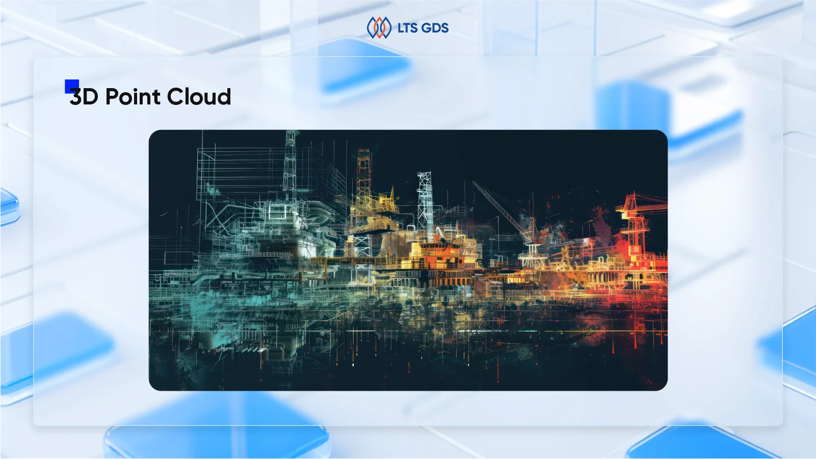
Point cloud data, in its simplest form, is a detailed digital representation of a 3D object. It’s created by high-tech tools like 3D scanners, LiDAR, and photogrammetric software, which measure the x, y, and z coordinates of countless points on an object’s surface. This comprehensive data capture method has revolutionized industries from architecture and engineering to autonomous vehicles and geospatial analysis.
The sophistication of modern point cloud technology extends beyond mere spatial coordinates. Advanced systems can capture additional attributes such as RGB color values, intensity measurements, and surface reflectance properties, transforming basic geometric data into rich, multi-dimensional datasets that provide unprecedented insights into physical environments.
The Technology Behind 3D Point Cloud Generation
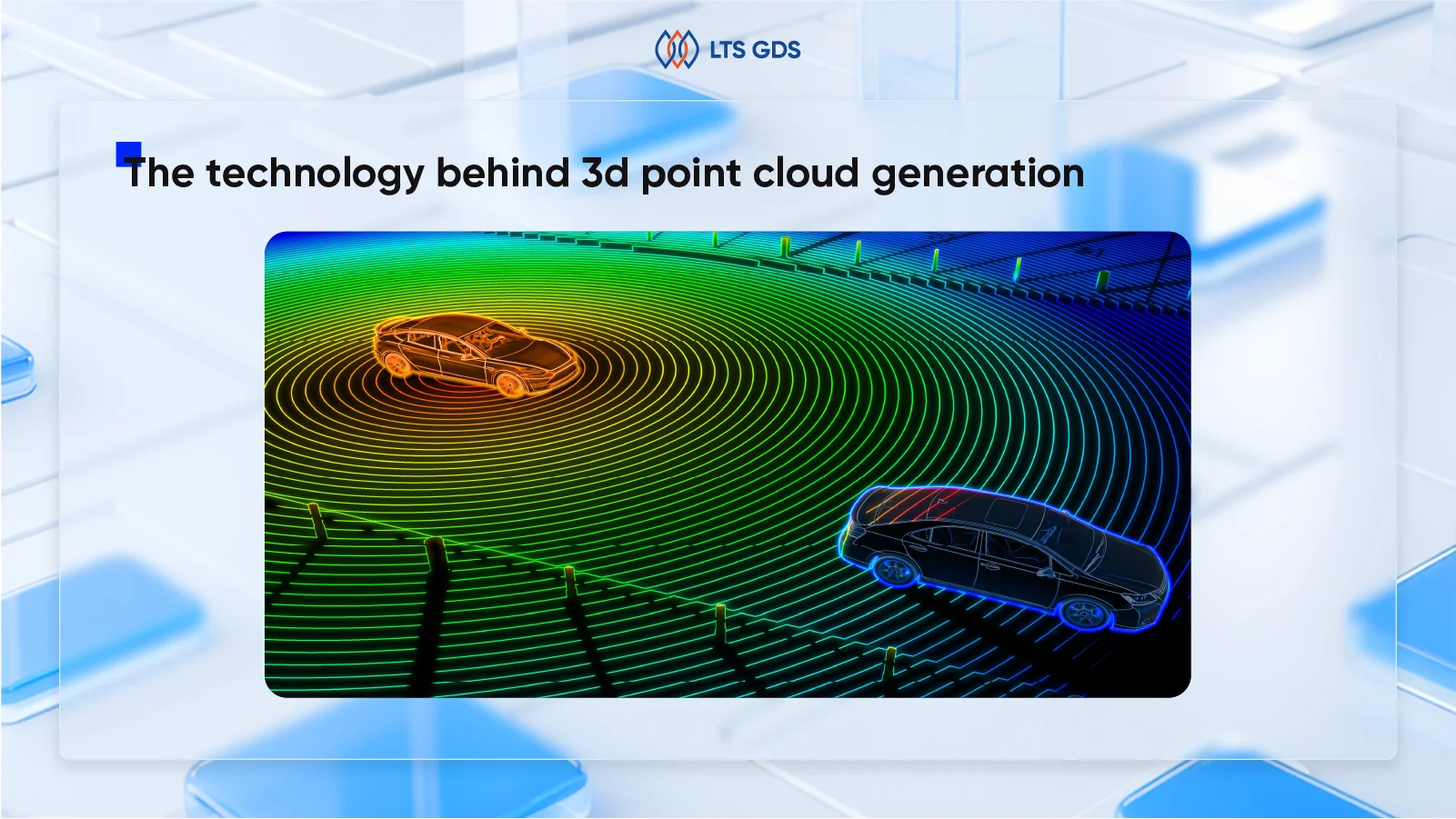
3D point clouds are primarily generated through advanced scanning technologies, with LiDAR (Light Detection and Ranging) being the most prevalent method in professional applications. LiDAR systems emit laser pulses toward a target and measure the time taken for the light to reflect back, calculating precise distances to create a dense map of points. This rapid-fire data collection enables comprehensive spatial mapping with remarkable efficiency, with modern systems capable of capturing up to two million points per second.
Advanced generation methods
Beyond LiDAR technology, several other sophisticated methods contribute to point cloud generation:
Structured-light scanning: This technique projects known patterns onto surfaces and analyzes the deformation of these patterns to calculate 3D coordinates. This method excels in controlled environments and provides excellent detail for smaller objects.
Photogrammetry: Utilizing multiple overlapping images captured from different angles, photogrammetry employs sophisticated algorithms to identify common features and triangulate 3D positions. This approach brings unique advantages, particularly in scenarios where color information is crucial, as photogrammetric point clouds inherently contain RGB values for each point.
Sonar and radar systems: These technologies prove invaluable for underwater or subsurface scanning applications, where traditional optical methods face limitations.
Time-of-flight cameras: These specialized cameras measure the time light takes to travel from the camera to objects and back, enabling real-time depth perception and point cloud generation.
Drone-based acquisition: Unmanned aerial vehicles equipped with LiDAR or photogrammetry sensors are increasingly deployed to capture point clouds of large or hard-to-access areas, enabling rapid, high-resolution data acquisition for surveying, construction monitoring, and environmental mapping. This aerial approach has revolutionized large-scale data collection, making previously inaccessible areas readily scannable.
The 3D Point Cloud Processing Workflow
Once raw point cloud data is captured, it undergoes comprehensive post-processing to transform it into actionable information. This sophisticated workflow ensures data quality, usability, and integration with downstream applications. Specialized point cloud software platforms facilitate this transformation by providing advanced tools for visualization, annotation, measurement, and conversion into usable 3D models.
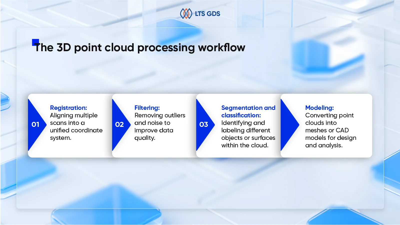
Key steps include:
- Registration: Aligning multiple scans into a unified coordinate system.
- Filtering: Removing outliers and noise to improve data quality.
- Segmentation and classification: Identifying and labeling different objects or surfaces within the cloud.
- Modeling: Converting point clouds into meshes or CAD models for design and analysis.
Registration and alignment
The first critical step involves aligning multiple scans into a unified coordinate system. When scanning large areas or complex structures, multiple scanner positions are typically required to capture complete coverage. Registration algorithms identify common features between overlapping scans and mathematically align them to create seamless, comprehensive datasets.
Data cleaning and filtering
Raw point cloud data often contains noise, outliers, and unwanted elements that must be removed to improve data quality. Advanced filtering algorithms identify and eliminate erroneous points caused by atmospheric conditions, moving objects, or scanner artifacts. This process significantly reduces dataset size while enhancing accuracy and usability.
Segmentation and classification
This crucial step involves identifying and labeling different objects or surfaces within the point cloud. Semantic segmentation techniques play a vital role in automatically classifying elements such as buildings, vegetation, roads, and vehicles within urban environment scans. The distinction between semantic segmentation vs instance segmentation becomes particularly relevant here, where the goal might be to identify not just object types but also distinguish between individual instances of similar objects.
3D modeling and mesh generation
Converting point clouds into meshes or CAD models enables design analysis and visualization applications. Surface reconstruction algorithms analyze point relationships to create triangulated surfaces that represent object geometry in formats compatible with standard design software.
Automated processing with AI
Emerging artificial intelligence and machine learning techniques are revolutionizing point cloud interpretation by automating tasks such as object detection and classification. These advanced systems require extensive training datasets with properly annotated samples, highlighting the critical importance of professional data annotation services in creating reliable training data for machine learning algorithms.
3D Point Cloud Applications Across Industries
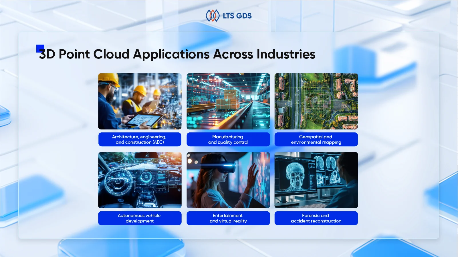
Architecture, engineering, and construction (AEC)
The AEC industry has embraced point cloud technology as a transformative tool for project delivery and asset management. Point clouds enable precise as-built documentation, renovation planning, and seamless Building Information Modeling (BIM) integration. They significantly improve accuracy in measuring distances, volumes, and angles, facilitating enhanced project management and collaboration among stakeholders.
For renovation and retrofit projects, point cloud data eliminates guesswork by providing architects and engineers with millimeter-accurate existing conditions. This precision enables conflict detection before construction begins, significantly reducing costly field changes and project delays. The technology’s ability to capture complex geometries and structural details makes it invaluable for historic preservation projects where traditional measurement methods prove inadequate.
Manufacturing and quality control
Manufacturing facilities increasingly utilize point cloud scanning for reverse engineering and quality control applications. Detailed 3D scans of parts and assemblies enable product refinement and optimized production workflows by revealing dimensional variations and surface defects invisible to traditional inspection methods. This application often requires sophisticated 3D image annotation techniques to properly categorize and analyze captured manufacturing data.
The technology proves particularly valuable in aerospace and automotive manufacturing, where precision tolerances and complex geometries demand exacting quality control measures. Point cloud scanning enables non-contact measurement of critical components, reducing handling damage while providing comprehensive dimensional analysis.
Geospatial and environmental mapping
High-resolution terrain models, topographic surveys, and infrastructure mapping are revolutionized by point cloud technology, often integrated with Geographic Information Systems (GIS) for comprehensive spatial analysis. Environmental monitoring applications leverage point cloud data to track changes in coastlines, forest canopies, and urban development patterns over time.
Large-scale surveying projects benefit enormously from aerial point cloud acquisition, enabling rapid mapping of extensive areas with unprecedented detail and accuracy. This capability proves essential for disaster response planning, environmental impact assessment, and resource management applications.
Autonomous vehicle development
The automotive industry extensively leverages point cloud technology in autonomous vehicle development. Real-time LiDAR systems generate continuous point cloud streams that enable vehicles to perceive their environment with extraordinary precision, detecting obstacles, road boundaries, and other vehicles with split-second accuracy.
This critical application highlights the importance of data annotation in the automotive industry, where precise labeling of point cloud data trains machine learning algorithms for safe autonomous navigation.
Entertainment and virtual reality
Point clouds serve as the principal for creating immersive virtual environments, realistic simulations, and cutting-edge augmented reality applications. The entertainment industry utilizes point cloud scanning to create photorealistic digital environments for films, video games, and virtual reality experiences, capturing real-world locations with unprecedented fidelity.
Forensics and accident reconstruction
Detailed 3D reconstructions of crime scenes and accident sites support investigations and legal processes, providing accurate spatial evidence even under challenging conditions such as low light or hazardous environments. Law enforcement agencies increasingly rely on point cloud technology to preserve scene evidence digitally, enabling detailed analysis long after physical evidence has been processed or removed.
Technical Challenges and Best Practices in 3D Point Cloud Processing
Processing 3D point clouds presents a range of technical challenges, driven by the complexity of real-world environments and the high dimensionality of the data. Effectively navigating these obstacles requires focused solutions and domain-specific best practices. Below, we outline the most common challenges, paired with proven approaches to address them efficiently.
1. Unstructured and irregular data distribution
Challenge:
3D point clouds consist of millions of points irregularly scattered in space, lacking a fixed grid structure. This makes spatial indexing, searching, and processing computationally intensive and algorithmically complex.
Solution & best practice:
Implement spatial indexing data structures such as kd-trees and octrees to accelerate nearest neighbor searches and spatial queries. These structures partition space efficiently, reducing search complexity. Additionally, leveraging GPU acceleration for parallel processing (e.g., CUDA-based ICP algorithms) can significantly speed up registration and matching tasks, enabling near real-time processing.
2. Noise and outliers
Challenge:
Sensor inaccuracies, environmental interference, and occlusions introduce noise and outliers into point cloud data, which degrade the quality of analysis and modeling.
Solution & best practice:
Apply robust filtering techniques such as Statistical Outlier Removal (SOR) and radius-based filtering to eliminate noise. Combining multiple filters can improve results. Preprocessing pipelines should include iterative noise reduction steps before further processing. Sampling strategies that preserve key geometric features while reducing data volume also help maintain data integrity.
3. Large-scale data volume
Challenge:
High-resolution scans generate massive datasets, often containing billions of points, which pose challenges for storage, transmission, and real-time processing.
Solution & best practice:
Utilize efficient data compression and hierarchical data structures like octrees to manage large datasets. Employ cloud-based storage and distributed computing platforms to scale processing capabilities. Implement streaming algorithms that process data in chunks rather than loading entire datasets into memory. This approach supports scalability and responsiveness in enterprise environments.
4. Varying density and sparsity
Challenge:
Point clouds frequently have uneven density due to sensor perspective or occlusion, complicating feature extraction and segmentation.
Solution & best practice:
Adopt adaptive algorithms that adjust processing parameters based on local point density. Hybrid approaches combining voxelization with point-based methods balance computational efficiency and detail preservation. For example, voxel grids simplify data for convolutional neural networks, while point-level features recover fine details lost in voxelization.
5. Semantic understanding and annotation
Challenge:
Assigning meaningful labels to unstructured point clouds is difficult due to irregular sampling and lack of inherent connectivity, making manual annotation time-consuming and error-prone.
Solution & best practice:
Leverage deep learning architectures designed for point clouds (e.g., PointNet, PointNet++) to automate semantic segmentation. Combine manual annotation with AI-assisted tools, employing active learning and semi-supervised methods to reduce human effort and improve accuracy. Iterative annotation workflows with continuous model retraining help scale annotation projects efficiently.
Future Trends in 3D Point Cloud Technology
3D point cloud technology is entering a new phase of rapid evolution, driven by breakthroughs in artificial intelligence, cloud computing, and multimodal data integration. These advances are transforming point clouds from static datasets into dynamic, intelligent spatial assets that underpin next-generation digital workflows.
AI-Powered automation and semantic understanding
Artificial intelligence is revolutionizing point cloud processing by automating complex tasks such as semantic segmentation, object detection, and anomaly identification. Modern deep learning models tailored for unstructured spatial data reduce reliance on manual annotation and accelerate the conversion of raw point clouds into actionable insights. This shift enables enterprises to build smarter perception systems that actively interpret their environments.
Cloud-native platforms and real-time collaboration
Cloud-based point cloud platforms are becoming the standard, offering scalable storage and powerful computing resources. These platforms facilitate real-time collaboration among distributed teams, allowing seamless data sharing, version control, and integrated workflows. This democratization of access empowers organizations to accelerate project timelines and improve decision-making across geographies.
Multimodal data fusion for enhanced spatial intelligence
Integrating point clouds with complementary data sources, such as high-resolution imagery, video, and GIS datasets, creates richer, more comprehensive 3D models. This fusion enhances robustness and context awareness, particularly in complex environments like urban infrastructure and industrial sites, enabling more precise analysis and simulation.
Real-time processing and on-site modeling
Advances in sensor technology and edge computing are enabling real-time point cloud capture and processing directly on-site. This capability reduces delays between data acquisition and actionable outputs, benefiting industries such as construction, manufacturing, and disaster response by enabling immediate quality control and rapid decision-making.
Immersive visualization and interaction
The convergence of point clouds with virtual and augmented reality technologies offers immersive environments for design review, training, and remote inspection. These interactive visualizations improve spatial understanding and stakeholder engagement, accelerating collaboration and reducing costly errors.
Emerging technologies shaping the future
Looking ahead, innovations like neural compression algorithms promise to reduce the storage and bandwidth demands of massive point cloud datasets without sacrificing detail. Photonic chips and specialized hardware will further accelerate processing speeds and energy efficiency. Although still in early stages, quantum computing holds transformative potential for solving complex spatial optimization problems at unprecedented scales.
FAQ about Video Annotation
1. How is 3D point cloud technology applied in healthcare beyond imaging?
Beyond 3D imaging for diagnosis and surgical planning, 3D point clouds enable precise modeling of internal organs and tissues, supporting personalized treatment simulations and improving outcomes in complex surgeries.
2. What additional data attributes can points in a 3D point cloud carry besides position?
Points often include extra information such as color (RGB), laser return intensity, number of returns, scanning angle, and timestamps, which enrich analysis by revealing material properties and environmental conditions.
3. How does LiDAR differ from other point cloud generation methods like photogrammetry?
LiDAR uses laser pulses to measure distance directly, producing highly accurate and dense point clouds even in low-light or complex environments, whereas photogrammetry reconstructs 3D shapes from overlapping 2D images, which can be less precise under certain conditions.
Partner with experienced providers
Key considerations when selecting a 3D point cloud annotation partner
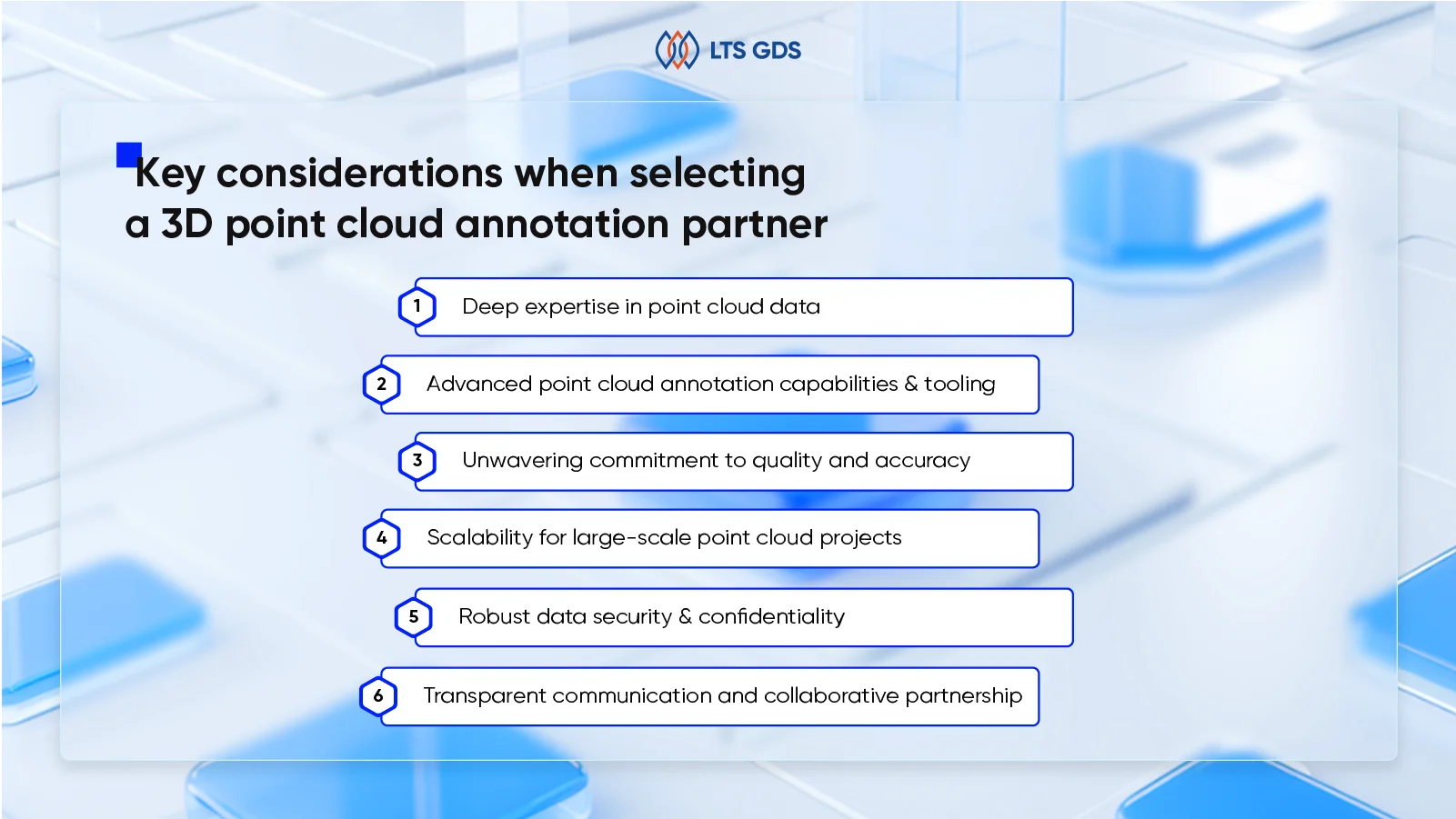
- Deep expertise in point cloud data
- Proven LiDAR/Point cloud experience
- Understanding of point cloud characteristics
- Temporal consistency for sequences
- Advanced point cloud annotation capabilities & tooling
- Proficiency with specialized tools
- Support for diverse annotation types
- Tool customization & automation
- Unwavering commitment to quality and accuracy
- Rigorous QA for point clouds
- Accuracy metrics for 3D
- Iterative refinement
- Scalability for large-scale point cloud projects
- Capacity for volume & velocity
- Efficient project management & workflows
- Robust data security & confidentiality
- Secure handling of sensitive data
- Compliance adherence
- Transparent communication and collaborative partnership
- Clear, proactive communication
- True collaboration
Deep expertise in point cloud data
- Proven LiDAR & point cloud experience
- Extensive work with diverse point cloud formats: .las, .laz, .pcd, .ply
- Handling sensor data from LiDAR, structured light, Time-of-Flight (ToF) systems
- Demonstrated success via case studies and portfolios on similar datasets
Mastery of point cloud characteristics
- Managing challenges: varying point densities, noise, occlusions, sensor fusion
- Accurate 3D geometry capture and semantic understanding in sparse/dense clouds
- Ensuring temporal consistency for sequential data (e.g., object tracking across frames)
Advanced annotation capabilities & tooling
- Skilled in 3D annotation tools supporting cuboid fitting, semantic & instance segmentation, polyline annotations
- Handling diverse annotation tasks: vehicles, pedestrians, terrain, vegetation, buildings
- Customizing tools and leveraging AI-assisted pre-labeling for efficiency on large datasets
Commitment to quality & accuracy
- Multi-stage QA processes checking dimensional accuracy, label correctness, and consistency
- Use of 3D accuracy metrics (3D IoU, precision/recall) with targets >98-99%
- Iterative refinement incorporating client feedback to improve annotation quality
Scalability for large-scale projects
- Capacity to scale workforce and infrastructure for high-volume, time-sensitive projects
- Optimized project management and data workflows tailored for point cloud complexity
Robust data security & compliance
- Strict data security protocols (ISO 27001 or equivalent), secure transfer (SFTP, VPN), and NDAs
- Compliance with regional data privacy regulations
Transparent communication & collaboration
- Proactive updates, clear reporting, and dedicated contacts
- Collaborative partnership acting as an extension of client teams, ensuring alignment with project goals
Making the Informed Choice with LTS GDS for Your Point Cloud Needs
The development of sophisticated 3D perception systems relies on the exceptional quality of the annotated point cloud data used for training. By rigorously evaluating potential partners against the above specialized criteria, organizations can secure a 3D point cloud annotation provider capable of meeting their demanding technical requirements and aligning with the project’s strategic ambitions.
At LTS GDS (Global Delivery Services), a core entity of LTS Group, we possess specialized expertise in Digital BPO services, including high-precision AI Data Annotation for complex 3D point cloud datasets. LTS GDS understands the critical importance of meticulous accuracy, robust scalability, and unwavering security when preparing point cloud data for advanced AI models in sectors like autonomous driving, robotics, and smart cities. Our teams leverage state-of-the-art annotation tools and are supported by stringent quality assurance processes to deliver point cloud annotation services that meet the highest industry standards.
With LTS GDS, an enterprise gains a dedicated partner committed to transforming their raw point cloud data into invaluable, model-ready intelligence, thereby empowering the organization to accelerate innovation and achieve leadership in their AI-driven endeavors.