Imagine a world where autonomous vehicles can instantly detect not just where objects are, but how fast they’re moving in real-time, through fog, rain, or complete darkness. This isn’t science fiction anymore. Welcome to the era of 4D LiDAR technology.
We advance toward fully autonomous systems, the limitations of traditional 3D sensing technologies have become increasingly apparent. While conventional LiDAR excels at creating detailed 3D maps of the environment, it struggles to provide immediate velocity information about moving objects – a critical capability for safe autonomous navigation at highway speeds.
4D LiDAR represents a paradigm shift in perception technology. By adding the fourth dimension of instantaneous velocity detection to traditional 3D spatial mapping, this revolutionary technology is enabling safer, smarter, and more efficient autonomous systems across multiple industries. From self-driving cars navigating complex urban environments to robots operating in smart factories, 4D LiDAR is transforming how machines perceive and interact with the world.
The global automotive LiDAR market is experiencing explosive growth, projected to reach $9.59 billion by 2030 from $1.19 billion in 2024, representing a remarkable 41.6% CAGR (Markets and Markets). This growth is driven by the push toward higher levels of vehicle autonomy and the integration of advanced perception technologies like 4D LiDAR.
Now, we’ll explore about this technology – from data labeling challenges to future innovations that will shape the autonomous revolution.
What Is 4D LiDAR?
4D LiDAR is an advanced remote sensing technology that captures four dimensions of data simultaneously: the three spatial coordinates (X, Y, Z) that define an object’s position in 3D space, plus an additional fourth dimension – instantaneous velocity. This capability to detect both where objects are and how fast they’re moving represents a fundamental advancement over traditional 3D LiDAR systems.
The technology builds on the foundation of standard LiDAR (Light Detection and Ranging), which uses laser pulses to measure distances and create detailed three-dimensional maps of environments. However, 4D LiDAR systems employ sophisticated techniques like Frequency Modulated Continuous Wave (FMCW) technology to directly measure the velocity of each point in the scene without requiring complex computational analysis of sequential frames.
The most significant advantage of this technology is its ability to provide instant velocity detection for every point in the point cloud. This means that perception systems can immediately distinguish between static objects (like parked cars or buildings) and dynamic objects (like moving vehicles or pedestrians).
How 4D LiDAR works?
Understanding how 4D LiDAR works requires examining both its technological foundations and how it differs from similar sensing technologies.
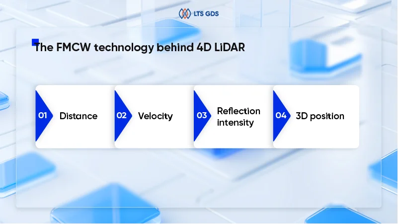
The FMCW technology behind 4D LiDAR
Most advanced 4D LiDAR systems utilize Frequency Modulated Continuous Wave (FMCW) technology, which represents a significant departure from traditional Time-of-Flight (ToF) LiDAR systems. Rather than simply measuring how long it takes for a laser pulse to return, FMCW LiDAR continuously transmits a laser beam whose frequency is modulated over time.
When the transmitted beam reflects off a moving object, it experiences a Doppler shift – a change in frequency based on the object’s velocity relative to the sensor. By measuring both the time delay and the frequency shift of the returned signal, FMCW LiDAR can simultaneously determine:
- Distance: Calculated from the time delay between transmission and reception
- Velocity: Derived from the Doppler shift in the returned signal’s frequency
- Reflection intensity: Providing information about surface properties
- 3D position: Through precise angular measurements
4D LiDAR vs 4D Radar: understanding the competition
The comparison between 4D LiDAR and 4D radar has become increasingly relevant as both technologies evolve to provide four-dimensional environmental perception. While they were once considered complementary technologies serving different purposes, modern advancements have placed them in direct competition, particularly in the autonomous vehicle market. To choose the right technology for each application, check the comprehensive side-by-side comparison below:
| Feature | 4D LiDAR | 4D Radar |
| Wavelength | Light waves (900-1550 nm) | Radio waves (77-81 GHz, ~4mm) |
| Range | Up to 500m for high-reflectivity targets; 200-300m typical | 250-300m typical; can exceed 300m |
| Spatial resolution | High (centimeter-level accuracy); 0.1-0.5° angular resolution | Moderate (1-2° angular resolution); improving with imaging radar |
| Weather performance | Degraded in heavy rain/fog/snow; improved over 3D LiDAR | Excellent; penetrates fog, rain, snow, dust |
| Object classification | Excellent (detailed shape recognition) | Good (improving with AI and higher resolution) |
| Small object detection | Excellent (detects debris, pedestrians at distance) | Limited (struggles with non-metallic small objects) |
| Night performance | Excellent (independent of ambient light) | Excellent (independent of ambient light) |
| Cost (current) | High ($2,000-$10,000+ per unit) | Moderate ($150-$500 per unit) |
| Cost trajectory | Rapidly decreasing | Mature technology; stable pricing |
| Best for |
|
|
Read more: LiDAR vs Radar in Autonomous Vehicles Race: A Comprehensive Comparison
Data labeling for 4D LiDAR
The promise of 4D LiDAR can only be realized through properly labeled training data. Data labeling for 4D LiDAR presents unique challenges and requirements that go beyond traditional 3D point cloud annotation.
The complexity of 4D LiDAR annotation
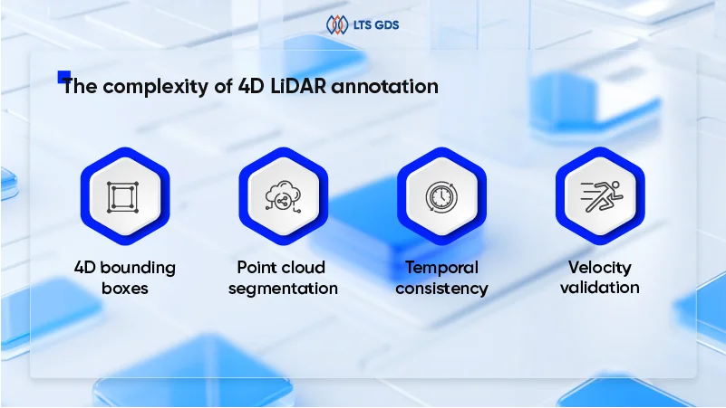
Annotating 4D LiDAR data involves labeling both the spatial (3D position) and temporal (velocity) information captured by the sensor. This creates several layers of complexity:
4D bounding boxes: Unlike 3D bounding boxes that simply define an object’s position and dimensions in space, this annotation must also capture velocity vectors. Annotators need to label not just “there’s a car here,” but “there’s a car here, moving at this speed in this direction.” This requires specialized annotation tools capable of handling the additional velocity dimension.
Point cloud segmentation: Beyond object detection, many applications require semantic segmentation where each point in the cloud is labeled with a class (road, sidewalk, vehicle, pedestrian, vegetation, etc.). The 3D nature of point clouds makes this more challenging than 2D image segmentation, as annotators must navigate through three-dimensional space and view objects from multiple angles to ensure complete and accurate labeling.
Temporal consistency: Data often comes in sequential frames showing how a scene evolves over time. Maintaining consistent labels across these frames, ensuring that the same car is tracked with the same ID through multiple frames while its velocity changes, requires sophisticated tracking algorithms and careful quality control.
Velocity validation: The velocity component of the data adds an extra layer of validation. Annotators must verify that velocity measurements are physically plausible and consistent with object trajectories. A parked car shouldn’t have velocity labels, while a moving vehicle’s velocity should align with its direction of travel.
Read more: LiDAR Annotation: Current Landscape and Future Directions
4D LiDAR vs. 3D LiDAR: What’s the difference
The evolution from 3D to 4D LiDAR represents more than just an incremental improvement, it’s a fundamental shift in perception capabilities that addresses critical limitations of conventional LiDAR systems.
| Feature | 3D LiDAR | 4D LiDAR |
| Dimensions captured | X, Y, Z (spatial coordinates) | X, Y, Z + Velocity (spatial + motion) |
| Technology | Time-of-Flight (ToF) | Frequency Modulated Continuous Wave (FMCW) |
| Velocity detection | Indirect (comparing sequential frames) | Direct (instantaneous Doppler measurement) |
| Range (standard targets) | 100-200m typical | 200-300m typical; up to 500m |
| Point cloud data | Position + Intensity | Position + Intensity + Velocity |
| Moving object tracking | Multi-frame processing required | Single-frame instant tracking |
| Weather performance | Moderate (degraded in fog/rain) | Improved (better signal processing) |
| 4D localization | Requires GPS/IMU integration | Standalone (velocity enables self-localization) |
| Ideal applications | Mapping, surveying, low-speed robotics, static scanning | Highway autonomy, dynamic environments, urban driving, safety-critical |
Top Industries Applying 4D LiDAR
The unique capabilities of 4D LiDAR – combining precise spatial mapping with instant velocity detection – are revolutionizing multiple industries. Let’s explore the sectors where this technology is making the biggest impact.
Autonomous vehicles and advanced driver assistance systems (ADAS)
The automotive industry is the primary driver of 4D LiDAR development and adoption. The technology addresses critical safety requirements that traditional sensors struggle to meet.
Long-haul trucking represents one of the most promising near-term applications for 4D LiDAR. Companies like Daimler Truck have selected Aeva’s 4D LiDAR for their autonomous Freightliner Cascadia trucks, targeting commercial deployment by 2027. The ability to detect and track vehicles, pedestrians, and obstacles at highway speeds (up to 500 meters away) is essential for safe autonomous operation on interstates and highways.
Industrial robotics and automation
Manufacturing and logistics facilities are deploying 4D LiDAR to enable safer, more efficient automated operations.
Autonomous Mobile Robots (AMRs): Warehouse robots equipped with 4D LiDAR navigate complex, dynamic environments where humans and machines work side by side. The instant velocity detection allows robots to:
- Predict collision paths with moving obstacles
- Maintain safe distances from workers
- Optimize routes around dynamic obstacles
- Handle unexpected situations gracefully
Companies like Unitree Robotics are producing affordable 4D LiDAR sensors (under $500) specifically designed for robotic applications, including logistics, intelligent distribution, and smart factories.
Automated Guided Vehicles (AGVs): In manufacturing plants, AGVs equipped with 4D LiDAR safely transport materials alongside human workers. The technology enables:
- Speed-dependent safety zones
- Dynamic path planning around moving obstacles
- Integration with factory management systems
- Reduced safety margins due to better perception (increasing efficiency)
Smart Factories: Fixed 4D LiDAR installations provide situational awareness across entire factory floors, enabling:
- Real-time occupancy mapping
- Worker safety monitoring
- Production flow optimization
- Integration with robotic systems for coordinated operations
The breadth of industries adopting 4D LiDAR demonstrates its versatility and transformative potential. While automotive applications currently drive development and investment, the technology’s ability to provide instant, accurate, privacy-preserving perception of dynamic environments makes it valuable across virtually every sector dealing with autonomous systems, safety monitoring, or complex operational environments.
Costs continue to decline and performance improves, we can expect even broader adoption, with 4D LiDAR becoming a standard sensing technology across robotics, automation, and smart infrastructure applications.
What’s Next for 4D LiDAR?
The journey of 4D LiDAR development points toward breakthrough innovations that will expand its capabilities and applications while making the technology more accessible.
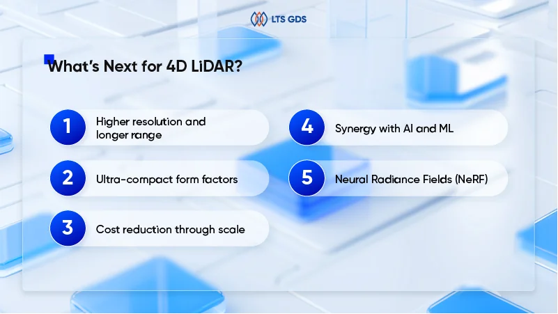
Higher resolution and longer range: Next-generation 4D LiDAR sensors are pushing performance boundaries:
- More detailed environmental understanding
- Better classification of distant objects
- Safer operation at higher speeds
- Reduced need for multiple sensors per vehicle
Ultra-compact form factors: The integration of LiDAR components onto single chips through silicon photonics is enabling dramatically smaller sensors.
Cost reduction through scale: Current automotive-grade 4D LiDAR sensors cost several thousand dollars. However, multiple factors are driving rapid cost reductions, such as scaled-up manufacturing and increased competition among OEMs in the future.
Synergy with AI and ML: The evolution of 4D LiDAR is intimately connected with advances in artificial intelligence:
Neural Radiance Fields (NeRF): Next-generation reconstruction techniques will leverage 4D LiDAR’s rich data to create photorealistic 3D models in real-time.
FAQs about 4D LiDAR
1. What is 4D LiDAR and how does it differ from 3D LiDAR?
4D LiDAR adds the temporal dimension to traditional 3D point clouds, capturing spatial coordinates (x, y, z) plus time-based data. This enables real-time tracking of moving objects, velocity estimation, and dynamic scene understanding. Unlike 3D LiDAR’s static snapshots, 4D LiDAR provides continuous motion data essential for autonomous vehicles, robotics, and industrial automation applications requiring precise object tracking and behavioral prediction.
2. Why is annotation quality critical for 4D LiDAR AI models?
Poor annotation quality in 4D LiDAR directly impacts model safety and performance, especially in high-stakes applications like autonomous driving. Inconsistent labeling across temporal sequences can cause tracking failures, misclassification of moving objects, or prediction errors. High-quality annotations ensure models accurately distinguish between static and dynamic elements, maintain object identity across frames, and make reliable real-time decisions.
3. What annotation types are required for 4D LiDAR data?
4D LiDAR annotation includes object detection and classification, 3D bounding box creation, semantic segmentation, instance segmentation, and temporal tracking across frames. Advanced applications require trajectory prediction labeling, velocity vector annotation, and behavioral classification.
The Road Ahead
4D LiDAR represents a watershed moment in perception technology. By adding instantaneous velocity detection to precise 3D spatial mapping, this technology addresses fundamental limitations that have constrained autonomous systems for decades.
4D LiDAR is not an emerging technology – it’s an arriving one. The companies that master its integration, develop robust perception algorithms that leverage its unique capabilities, and build the supporting infrastructure (including high-quality training data) will lead the next wave of autonomous innovation.
Ready to explore how 4D LiDAR can transform your sensing capabilities?
Contact LTS GDS today to discuss your specific requirements and discover how our annotated data powers AI models. The future of intelligent sensing starts with your next decision.